
Waterspouts: How They Form and How to Steer Clear at Sea
Waterspouts come in fair weather and tornadic forms. How they build, the five stage life cycle, and the NOAA rule for steering clear of one.
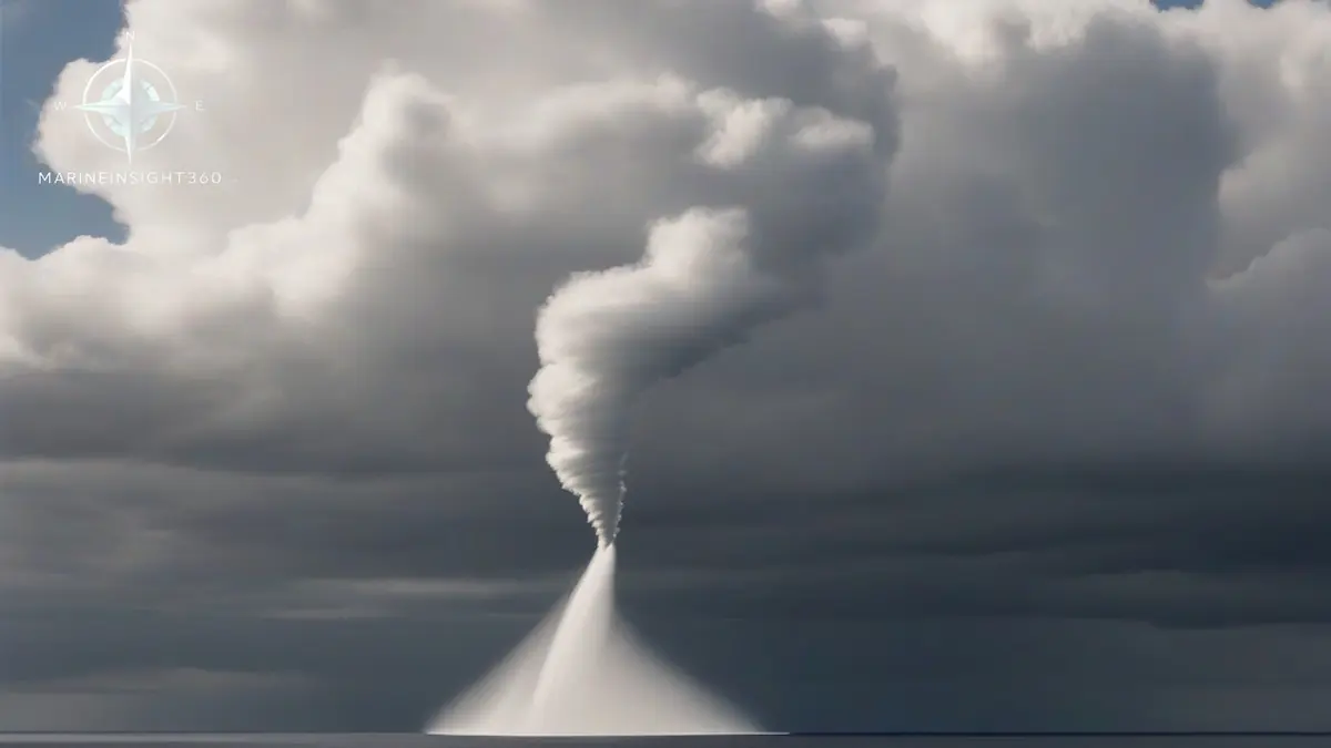
A waterspout is a rotating column of air over water, connected to a cumulus or cumulonimbus cloud base. NOAA divides them into two kinds. Fair weather waterspouts build upward from the sea surface under a line of developing cumulus in light wind and strongly unstable air. Tornadic waterspouts are tornadoes over water, descending from a severe thunderstorm with the vertical wind shear, hail and lightning that go with it.
The avoidance rule for both is the same and it is worth memorizing: move at 90 degrees to the waterspout's apparent motion, never try to outrun it along its track.
The five stages of a fair weather waterspout
Research on fair weather waterspouts identifies a consistent life cycle, and the first stage appears on the water before any funnel is visible in the sky. That gives an alert bridge watch a genuine head start.
- Dark spot. A prominent circular light-colored disc with a darker surrounding patch appears on the sea surface.
- Spiral pattern. Alternating light and dark bands develop around the dark spot.
- Spray ring. A cascade of spray, the spray vortex, forms around the dark spot.
- Mature vortex. The funnel becomes visible from sea surface to cloud base, and this is when the wind is strongest.
- Decay. The funnel weakens and dissipates, often as rain-cooled air reaches the circulation.
A visible funnel is only the condensed part of the vortex. The damaging circulation extends beyond it, above and around, so an apparently short funnel is not a small hazard.
Tornadic waterspouts are the ones that damage ships
Tornadic waterspouts form the same way land tornadoes do, in an environment of strong instability and vertical wind shear, and they are embedded in severe thunderstorms. Expect the whole package: sudden squall winds, high confused seas, large hail, frequent lightning and near-zero visibility in rain. They can also come ashore as tornadoes, which matters to port and terminal operations as much as to ships.
NOAA notes that waterspouts have overturned boats, damaged large ships and put lives at risk. On a merchant ship the realistic damage list is broken bridge windows, displaced deck cargo and lashings, injury to anyone caught on an open deck, and damage to lifeboat covers, aerials and radar scanners.
The avoidance rule and how to apply it
The National Weather Service guidance is to move at right angles to the apparent movement of the waterspout. The reasoning is simple. Steering directly away puts the ship on the same track, and a waterspout can easily move faster than a loaded vessel can accelerate. A 90 degree course change takes the ship off the track in the shortest distance.
- Plot the spout's bearing repeatedly. A steady bearing with a closing range means it is heading for you.
- Alter early and boldly. Small alterations waste the geometry.
- Never pass ahead of the track to save distance.
- Remember that fair weather waterspouts often form in lines along a developing cumulus band, so one sighting suggests more behind it.
What to do when avoidance is not possible
In restricted water, at anchor, or alongside, altering course may not be an option.
- Get everyone off open decks and out of accommodation spaces with large windows.
- Close weathertight doors, hatches and ventilators, and stop cargo and bunkering operations.
- Secure loose deck gear, gangways, awnings and crane booms.
- Have the engine ready for immediate manoeuvre and consider veering more cable at anchor.
- Warn adjacent craft and the port authority on VHF.
Where and when to expect them
Waterspouts need warm water and an unstable air mass above it. NOAA identifies the Florida Keys as the most active waterspout area in the world, and the wider Gulf and Caribbean, the Adriatic and the Aegean see them regularly. The Great Lakes produce them in late summer and autumn when cold air moves over water that is still warm, and the same mechanism generates them off northwest European coasts in autumn.
Fair weather events favor light-wind mornings with a line of building cumulus and a flat sea.
Warnings, reporting and the limits of radar
When the National Weather Service suspects a storm may produce a waterspout, or when one is reported, it issues a Special Marine Warning. Keep the VHF weather channel and NAVTEX under watch in known waterspout areas. Radar rarely resolves the vortex itself, and small fair weather spouts often produce no radar signature at all, so the lookout remains the primary sensor.
Report any sighting to the coastguard with position, time, bearing and estimated movement. That report is what triggers the warning for the ship behind you. The Marine Insight 360 Maritime Safety section covers heavy weather bridge procedures in more depth.
Responsibility for the warning is worth knowing. The National Weather Service issues the Special Marine Warning, the USCG rebroadcasts urgent marine information on VHF and answers the distress call, and in United Kingdom waters the Maritime and Coastguard Agency runs the same function. A sighting reported with position, time and movement is what lets either service warn the ship behind you.
Where crews get caught out is the sudden shift rather than the mean wind. A vessel at anchor can drag or break out when the squall veers through 90 degrees, and cargo work stopped late leaves a crane boom or a gangway to be damaged. Small craft capsize. On merchant ships the casualties reported are usually injuries to people who stayed on deck to secure gear.
Sources and further reading
- What is a waterspout? NOAA Ocean Service
- Waterspouts, National Weather Service Miami
- Waterspouts, NOAA Ocean Today
What to read next
Recommended Reading
Marine Scrubbers: Types, How They Work and Where the Rules Are Tightening
How marine scrubbers strip sulfur from ship exhaust, the difference between open-loop, closed-loop and hybrid systems, and where washwater discharge is banned.
10 of the World's Greatest Natural Harbors, and Why They Matter
What makes a natural harbor, and ten of the world's greatest: Sydney, San Francisco, New York, Rio, Halifax and more, with the geography that shelters them.
How Katabatic Winds Form and Why They Catch Ships Out
Katabatic winds form when cold dense air drains downhill under gravity. How they build, where they hit hardest, and how to plan anchoring around them.