
What Is an Ocean Ridge? Inside the Longest Mountain Range on Earth
What an ocean ridge is, how mid-ocean ridges form, the scale of the 65,000 km system, and why the longest mountain range on Earth matters.
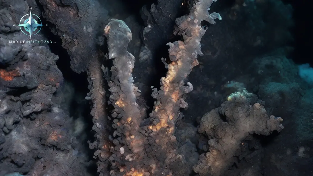
What is an ocean ridge? It is a continuous chain of underwater volcanic mountains, usually called a mid-ocean ridge, that forms where tectonic plates pull apart and new seafloor is created. The global system runs about 65,000 km (40,400 miles), wrapping the planet like the seams on a baseball, and it is the longest mountain range on Earth.
More than 90 percent of that range lies deep underwater, which is why most people have never heard of the planet's largest geological feature. The National Oceanic and Atmospheric Administration puts the average depth to the ridge crest at about 2,500 meters (8,200 feet).
How an ocean ridge forms
Mid-ocean ridges sit on divergent plate boundaries, the lines where two tectonic plates move apart. As the plates separate, hot mantle rock rises to fill the gap, melts as the pressure drops, and erupts as basalt lava on the seafloor.
Each eruption adds a strip of new oceanic crust to the trailing edges of both plates. The process, called seafloor spreading, runs at a few centimeters a year, roughly the speed at which fingernails grow. Over millions of years it has paved every ocean basin on the planet.
Fresh, hot crust near the ridge axis is buoyant, which is why ridges stand kilometers above the surrounding abyssal plains. As crust ages and cools it grows denser and subsides, producing the deep, flat seabed found far from the ridge.
The scale of the system, ocean by ocean
The Mid-Atlantic Ridge runs down the center of the Atlantic from the Arctic toward the Southern Ocean, neatly bisecting the ocean between the Americas on one side and Europe and Africa on the other. It is a slow spreading ridge with a deep central rift valley.
The East Pacific Rise spreads much faster and has a smoother, broader profile. Other branches thread the Indian Ocean and connect the whole network into one system. End to end, the system dwarfs any mountain chain on land, yet it was essentially unmapped until echo sounding surveys in the mid twentieth century revealed a continuous ridge with a rift running along its crest.
In a few places the ridge breaks the surface. Iceland is the most famous example, a country built where the Mid-Atlantic Ridge coincides with a volcanic hotspot, and one of the only places to walk across a spreading boundary on dry land.
Hydrothermal vents: life without sunlight
Where seawater seeps into hot, fractured young crust, it returns superheated and loaded with dissolved minerals. Vent fluids can exceed 300 C (572 F) yet do not boil, because of the immense pressure at depth. These hydrothermal vents build mineral chimneys and support dense communities of tube worms, shrimp, clams and microbes.
The organisms live by chemosynthesis, drawing energy from chemicals in the vent fluid rather than from sunlight. Their discovery in the late 1970s rewrote assumptions about where life can exist, and vent systems remain a priority for research programs such as NOAA Ocean Exploration expeditions along the Mid-Atlantic Ridge.
Why ocean ridges matter beyond the science
Ridges shaped the charts mariners use. The magnetic stripes recorded in ridge basalt confirmed plate tectonics, and modern bathymetric surveys of ridge systems feed the depth data behind ocean passage planning.
Submarine cable routes must cross ridge systems, and planners route around the roughest volcanic terrain and fracture zones. Vent fields also contain metal rich sulfide deposits, which has made ridge areas central to the debate over deep sea mining and its environmental cost.
Ridge volcanism even touches navigation warnings. Submarine eruptions can produce floating pumice rafts and new shoals, which is one reason hydrographic offices keep updating charts of remote ridge segments.
Ridges, trenches and the full conveyor
Mid-ocean ridges are one half of a planetary loop. Crust born at ridges travels slowly across the ocean basin and is eventually destroyed at subduction zones, the deep trenches where one plate slides beneath another.
That loop recycles the seafloor over a timescale of roughly 200 million years, which is why oceanic crust is young compared with the continents. For a working definition, remember it this way: an ocean ridge is the construction site of the seafloor. The Glossary at Marine Insight 360 covers related terms such as seamount, abyssal plain and trench.
Little of this terrain has been surveyed to modern standards. Charted depth over a ridge often comes from satellite altimetry and widely spaced single beam lines, so a pinnacle can sit between the tracks. Warnings about new shoals, floating pumice and submarine eruptions reach ships through the World-Wide Navigational Warning Service, coordinated by the IMO with the International Hydrographic Organization.
The consequences are concrete. Ships have grounded and touched bottom on features that were not on the chart, and submarine cables fail where routes cross seismically active fracture zones. A sounding that materially disagrees with the chart goes to the hydrographic office as a hydrographic note or its national equivalent. An unreported discrepancy is how a wrong charted depth survives for decades.
Sources and further reading
- What is a mid-ocean ridge? (NOAA Ocean Exploration)
- Multimedia Discovery Missions: Mid-Ocean Ridges (NOAA Ocean Exploration)
- Voyage to the Ridge 2022 expeditions (NOAA Ocean Exploration)
What to read next
Recommended Reading
Container Tracking: How Shippers Actually Follow a Box Across the Ocean
How container tracking works, from free carrier lookups to visibility platforms: what each tool layer does, what it costs, and how to pick for your volume.
What are Mid-Ocean Ridges: Earth's Underwater Mountain Chains
Mid-ocean ridges are giant underwater mountain ranges formed by the constant movement of plates and the heat and magma that erupt from the Earth's core.…
Hanwha Ocean Wins Qatari LNG Carrier Orders: Inside the QatarEnergy Fleet Build
Hanwha Ocean has booked more 174,000 cbm LNG carriers for the QatarEnergy programme. What the contracts, prices and delivery slots mean for the LNG trade.