
What Marine Navigation Systems & Electronic Instruments Do Ship Captains Use?
Today, modern technology has made navigation in restricted waters a highly specialized profession. With the latest developments in navigation methods and…

What Marine Navigation Systems And Electronic Instruments Do Ship Captains Use?
Today, modern technology has made navigation in restricted waters a highly specialized profession. With the latest developments in navigation methods and techniques, tools, hardware, and software are constantly evolving.
Gone are the days of anchoring in fog or snowstorms with near-zero visibility. Gone are the days of determining position by drawing lines using direction indicators and referring to external reference points on the waterway.
In the past, a ship's position was determined by the intersection of lines on a map. This intersection was called a "fix." Today, the Global Positioning System ( GPS ), also known as the Space-Assisted Global Positioning System (SAGPS), has become dominant and an integral part of virtually all types of navigation, whether air, land, or sea. Furthermore, new advanced control systems are constantly being developed to improve GPS's accuracy and efficiency.
Today, every ship uses a variety of navigation instruments and equipment to ensure maximum safety.
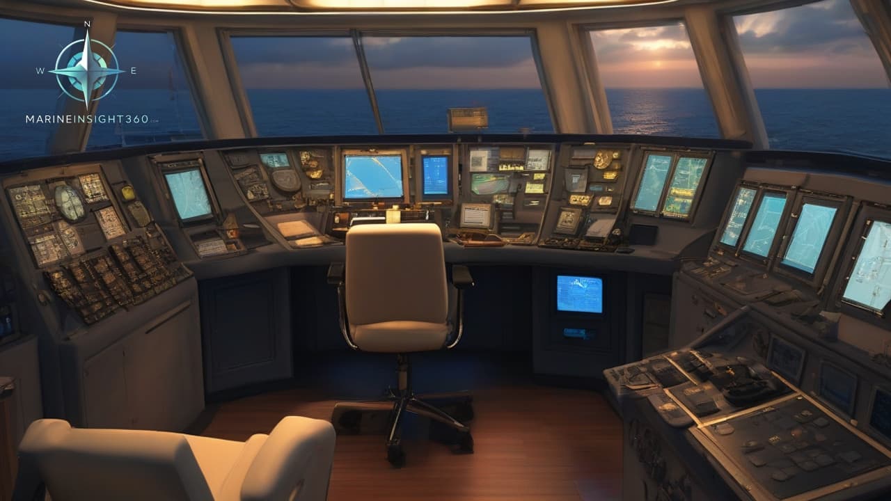
Maritime Navigation Systems
Previously, mariners relied entirely on paper nautical charts. Nautical charts are official databases maintained by government hydrographic offices and drawn on paper. These charts provide a two-dimensional view of the seabed or river and its topography, facilitating safe navigation.
The charts also indicate navigation hazards, sudden rises in the seabed, sunken vessels obstructing navigation in prohibited waters, the locations of any local industrial facilities, bridges, ports, and onshore installations, as well as the locations of buoys, towers, obelisks, and other coastal reference points. Hydrographic offices compile and update these charts after gaps occur, making navigation vulnerable to sudden changes in the seabed.
Physical charts take up a significant amount of space in the bridge chart room where they are stored. To address this, electronic nautical charts were developed, facilitating the transition from paper to digital.
There are two main types of electronic nautical charts: raster charts and vector charts. The former are simply scanned copies of the paper charts we discussed earlier, while the latter are more data-driven. Although hidden, data for a specific location is instantly revealed upon search (at the click of a button). This information disclosure is achieved by customizing the electronic charts using navigation software such as the Electronic Chart Display Information System ( ECDIS ).
All electronic nautical charts conform to the guidelines of the International Hydrographic Organization (IHO). Furthermore, these charts are regularly updated in accordance with IMO resolutions, which urge member governments to conduct hydrographic surveys and publish navigational information to ensure safe navigation. Member governments should coordinate as necessary to update this information and ensure that published charts are as uniform as possible.
everal very useful nautical charting programs are available. One such program is SEA CLARE, a computer program for Windows 2000 and later. When connected to a GPS, the program displays the vessel's current position, speed, and heading in real time. New maps can be automatically imported into a text file, and routes can be saved for later review. Entries can also be updated and entered manually. Multiple waypoints can be created to aid navigation.
However, GPS transmission must be the newer version known as NMEA 0183 (a specification or protocol developed by the National Marine Electronics Association of Maryland, USA).
Other bridge equipment compatible with this protocol can be connected to display various data alongside the map on the screen. For example, data such as water depth under keel, wind direction, gyroscopic ship position, and even Automatic Identification System ( AIS ) data can be transmitted to identify nearby vessel movements.
A simpler version, called a PC PLOTTER, is commonly used by small yachts and fishing boats. It is equipped with a low-cost, dual-channel, parallel AIS receiver capable of receiving signals from both large and small vessels.
AIS is a ship tracking system that determines the position of nearby vessels by automatically exchanging data with nearby vessels and AIS base stations. Ports with heavy traffic offer local Vessel Traffic Management Systems (VTMS)/Vessel Traffic Services (VTS), but AIS can be used as an additional support tool. You can find more detailed information about AIS here.
Another tool that reduces the workload of watchkeeping officers and pilots is a maritime radar equipped with an ARPA system. Radar , as we all know, is a radio detection and ranging device that reflects electromagnetic waves. Ships, aircraft, buildings, motor vehicles, marshes, bodies of water, and low clouds all reflect radio waves, making them visible on the screen.
The ARPA system can calculate the speed and direction of the tracked vessel and predict the nearest point of approach. It can also calculate the relative speed between the vessel and a fixed point (such as land) and determine the point and time of collision. Modern integrated ARPA systems have replaced older standalone systems, providing captains and crews with better observations.
The Norwegian company Maris offers the Pilot Mate, another ECDIS-based chart system that integrates quickly with bridge instruments. The system receives real-time email updates on available drafts, tide information, true-color ENC buoy display, and update log management. Additional features include route planning and tracking.
So we're seeing that the practice of drawing maps using dividers, fixed grids, hexagons, and other tools has been replaced by a digital environment on the bridge that virtually eliminates the possibility of human error. A truly digital system on the bridge virtually eliminates the possibility of a ship running aground or being completely lost at sea.
More from the Blog
Important Points for Committing Cargo Quantities in Tanker Ships
Committing cargo quantities on tanker ships is a critical commercial and operational decision. Whether it is crude oil, refined petroleum products,…

What is Displacement of a Ship ?
Imagine a colossal container ship like the Ever Given, stuck in the Suez Canal back in 2021. That beast weighs over 200,000 tons when fully loaded,…

Understanding Cruise Ship Hull Design
Cruise ships rely on hull shapes that blend form with function. Designers pick shapes to cut through water with less effort. This boosts speed and cuts…