
The Devil's Sea: Real Hazards Behind Japan's Dragon Triangle
The Devil's Sea south of Tokyo has a mythical reputation and a real hazard list: submarine volcanoes, the Kuroshio Current, typhoons and pumice rafts.
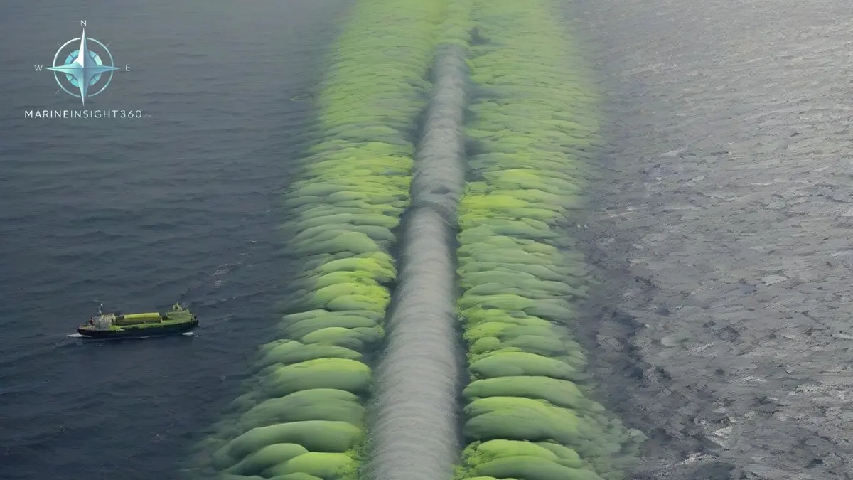
The Devil's Sea is a stretch of the Philippine Sea south of Tokyo, roughly between Miyake-jima, the Izu and Ogasawara island chains and the open Pacific. It is often called the Dragon's Triangle and marketed as a Pacific version of the Bermuda Triangle. There is no evidence that ships and aircraft vanish there at an unusual rate.
There is very good evidence that the area carries a specific and unusual set of navigational hazards, and those are worth a passage planner's attention.
The hazards are geological rather than supernatural. This water sits on the Pacific Ring of Fire, above a chain of active submarine volcanoes that can erupt with little warning, in a strong western boundary current, on the main typhoon corridor into Japan.
Where the Devil's Sea actually is
No chart carries a boundary for it, which is part of why the story survives. Descriptions place the western edge near Miyake-jima, about 100 km (54 nm) south of Tokyo, running south through the Izu and Bonin islands toward Iwo Jima, with wider versions stretching toward Taiwan or Guam. Since the area has no official definition, any statistic about losses inside it can be made to say whatever the writer wants.
Where the legend came from
Chinese and Japanese folklore about dragons taking ships from these waters is centuries old. The modern version dates from Western paperbacks of the 1970s and 1980s that recycled Bermuda Triangle claims onto a Pacific map, including a widely repeated assertion that the Japanese government declared the area a danger zone. That claim does not stand up.
What did happen was a cluster of postwar fishing vessel losses in the late 1940s and early 1950s, in an era of small wooden boats, no radar and no reliable radio, working an ocean with genuine volcanic hazards.
The 1952 loss that gave the story a real event
In September 1952 the Japanese survey vessel Kaiyo Maru No. 5 was lost with all 31 people on board while observing eruptive activity at Myojin-sho, a submarine volcano in the Izu island chain. Debris recovered later was consistent with the ship being destroyed by an explosive eruption directly beneath or beside her.
This is the core of the legend, and it is also a straightforward lesson in station-keeping near an active vent. A submarine eruption can throw rock, generate a local wave, and reduce water density with rising gas to the point that a hull loses buoyancy. Standing off is not caution; it is the only survivable option.
The hazards that are genuinely there
- Active submarine volcanoes. Fukutoku-Okanoba, Nishinoshima, Myojin-sho and the Bayonnaise Rocks have all been active in living memory. New shoals appear, existing ones deepen, and charted depths in the area age quickly.
- Discolored water. Yellow, green, brown or milky patches are the visible sign of a vent below. The Japan Coast Guard Hydrographic and Oceanographic Department monitors these and issues warnings when discoloration is seen. Treat any reported patch as a no-go area and pass upwind.
- The Kuroshio Current. This warm western boundary current runs northeast along the Japanese archipelago at rates reported up to about 4 knots. Against a strong opposing wind it builds short, steep, dangerous seas, and its meanders move enough to change passage times noticeably.
- Typhoons. The area sits directly on the recurving track that typhoons take toward Japan, with a season running roughly from May to November.
- Seismic activity. Earthquakes here can generate tsunami that are barely noticeable in deep water but destructive at the coast, which matters most for ships alongside or at anchor.
Pumice rafts, an underrated machinery hazard
A large submarine eruption can produce floating pumice covering a wide area of sea surface and drifting for months. Pumice is abrasive and it blocks things. It clogs sea chests and cooling water strainers, chokes generator and main engine cooling, damages pump impellers, and can shut down a ship's power in open water. The 2021 eruption at Fukutoku-Okanoba sent pumice drifting hundreds of miles to Okinawa and the Japanese mainland, disrupting ferries, fishing vessels and harbors.
The practical response is simple and it belongs in the passage plan, not in the engine room afterwards. Monitor navigational warnings for pumice drift, avoid transiting visible rafts, reduce speed if you must pass through, switch to high sea suction, and increase the frequency of strainer inspection while any risk remains.
What passage planning through the area should include
- Check NAVAREA XI warnings, which Japan coordinates, along with Japanese Notices to Mariners for new shoals and eruption exclusion zones.
- Confirm the chart edition and any temporary and preliminary notices covering the Izu and Ogasawara chains, where depths change.
- Plot the current Kuroshio axis for the passage, since it can add or cost real time and changes sea state sharply at its edges.
- Set a standing instruction that discolored water, floating pumice or unexplained shoaling is reported to the master and to the coastal authority.
- Brief the engine room on cooling water precautions before entering the area rather than after the first alarm.
Why the disappearance statistics do not hold up
The same argument that dismantles the Bermuda Triangle applies here. Heavily travelled water with severe weather and volcanic activity produces casualties, and the number is not out of line with traffic density once you count the traffic. The Devil's Sea deserves respect because of what is under it and what blows across it, not because of what is written about it.
Next step: before your next Japan passage, pull the current NAVAREA XI warnings and cross-check them against the volcanic activity reports for the Izu and Ogasawara chains. The Marine Insight 360 Knowledge Base covers passage planning and navigational warning sources in more detail.
The warning system behind those broadcasts is not Japanese alone. NAVAREA XI is one sea area of the World-Wide Navigational Warning Service, run jointly by the IMO and the International Hydrographic Organization, and Japan is the coordinator that issues the warnings for it. A new shoal or an eruption exclusion zone therefore reaches a ship in the Izu chain through the same channel as a warning in any other ocean.
Pumice damage leaves a paper trail once it happens. A blocked sea chest or a wrecked cooling pump becomes a class matter, surveyed by the vessel's society, ClassNK for much of the Japanese fleet, and a machinery damage claim against hull underwriters. Logged evidence that the crew tracked the warnings, avoided visible rafts and inspected strainers separates a covered casualty from an argument about negligence.
Sources and further reading
- Smithsonian Global Volcanism Program: Ioto (Japan Coast Guard eruption reports)
- Smithsonian Global Volcanism Program: Nishinoshima
- Explorersweb: Exploration Mysteries, The Devil's Sea
What to read next
Recommended Reading
Are Sea Serpents Real? The Animals Behind Sailors Sightings
No verified sea serpent has ever been documented, but oarfish, giant squid, decaying carcasses and sea mirages explain most sightings. Here is the evidence.
Where Are Most Cruise Ships Registered? The Flags Behind the Fleet
Most cruise ships are registered in the Bahamas, Panama, and Malta. Learn why open registries dominate cruising and what a flag state actually does.
The Hull of a Ship: Purpose, Design and the Trade-offs Behind It
What a ship hull does, how naval architects shape it, and why block coefficient, bulbous bows, stern form and double hulls change fuel burn and survivability.