
What is ODAS (Ocean Data Collection System)?
Beneath satellite feeds, weather forecasts, and ship routing algorithms lies a vast, often invisible infrastructure of floating instruments quietly…

What is ODAS (Ocean Data Acquisition System)?
Introduction: The Silent Sentinels of the Sea
Beneath satellite feeds, weather forecasts, and ship routing algorithms lies a vast, often invisible infrastructure of floating instruments quietly measuring the ocean. These systems — moored in some of the world's most remote and hostile marine environments — are the original source of the real-time data that powers modern maritime operations, climate science, storm prediction, and offshore engineering. They are called ODAS: Ocean Data Acquisition Systems, and without them, our understanding of the ocean would be startlingly limited.
For marine engineers, hydrographers, port operators, and offshore energy developers, ODAS represents one of the most critical — and frequently underappreciated — components of the global maritime information ecosystem. Whether you are designing an offshore structure that must survive a 100-year storm, routing a vessel through developing weather, or building a predictive model of coastal sediment transport, the data flowing from ocean data collection systems underpins your work at every turn.
This comprehensive guide explores what ODAS is, how it works, the technologies that power it, how it is deployed and maintained, and why it is becoming more important than ever in an era of climate change, offshore energy expansion, and autonomous maritime operations. If you work in or around the maritime industry, understanding the ocean data collection system concept isn't just useful — it's essential.
What is ODAS? Defining the Ocean Data Acquisition System
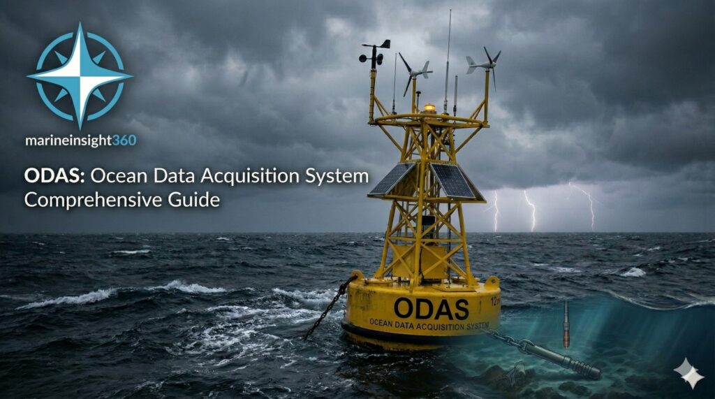
The term ODAS stands for Ocean Data Acquisition System . It refers to any instrumented platform — most commonly a moored or drifting buoy, but also including fixed seafloor installations and semi-submersible platforms — that autonomously measures physical, chemical, and biological parameters of the ocean and atmosphere, and transmits that data in near-real-time to shore-based users and global data networks.
The concept of the ocean data collection system emerged formally in the 1960s and 1970s as the maritime and scientific communities recognized that ship-based observations, while valuable, could never provide the continuous, simultaneous, and geographically widespread coverage that operational oceanography demanded. A research vessel can be in only one place at a time. An ODAS buoy, once deployed, observes continuously — in all weather, at all hours — for months or years at a stretch.
ODAS vs. Traditional Ocean Observation Methods
To appreciate the significance of ODAS, it helps to understand what preceded it. Traditional ocean observation methods include:
- Ship-based measurements: Conducted during voyages, providing spatially distributed but temporally discontinuous snapshots of ocean conditions
- Coastal tide gauges: Highly accurate at fixed coastal points but geographically limited to shorelines
- Manual weather stations on lightships and platforms: Dependent on human operators and limited in sensor capability
- Expendable bathythermographs (XBTs): Deployed from ships to measure temperature profiles, but single-use and limited in spatial coverage
Each of these methods has genuine value — and each remains in use today — but none can match the combination of continuity, autonomy, spatial coverage, and data density that a well-deployed network of ocean data acquisition systems provides. ODAS platforms occupy the unique operational niche of persistent, in-situ observation: they are physically present in the water column, measuring real conditions with calibrated instruments, continuously and automatically.
The Architecture of an Ocean Data Collection System
Understanding what makes ODAS work requires looking at the system architecture in some depth. A modern ocean data acquisition system is an integrated engineering platform, combining mechanical, electronic, power, and communications subsystems into a coherent whole capable of sustained autonomous operation.
The Buoy Hull and Superstructure
The most visible element of any ODAS deployment is the buoy hull — the physical platform that provides buoyancy, structural support, and above-water sensor mounting. ODAS buoy hulls come in several configurations, selected based on the deployment environment and measurement objectives:
Discus Buoys: The classic discus-shaped hull, ranging from 3 to 12 meters in diameter, is the workhorse of offshore ocean monitoring. Its flat, wide geometry provides a stable platform with relatively low wave-induced motion, making it well-suited for meteorological measurements that require a steady, representative sensor platform. The NOAA National Data Buoy Center (NDBC) operates the largest fleet of discus buoys in the world, with 3-meter and 6-meter hull variants deployed across both the Atlantic and Pacific Oceans.
Foam/Foam-Hull Buoys: Smaller, lighter, and lower-cost than steel discus buoys, foam-hull designs are widely used for nearshore and coastal ocean data collection deployments. Their simplicity makes them easier to deploy and service, though they offer less payload capacity and are more vulnerable to vandalism and vessel strike.
Toroidal (Donut) Buoys: The toroidal hull design , with its distinctive ring shape, offers superior wave-following characteristics compared to the discus for certain oceanographic measurements. The central void in the toroid allows for vertical profiling instruments or underwater equipment deployment through the hull center.
NOMAD Buoys: The NOMAD (Navy Oceanographic Meteorological Automatic Device) buoy, with its characteristic boat-shaped steel hull, was one of the earliest purpose-designed ODAS platforms and remains in service in some locations due to its exceptional seakeeping characteristics in high sea states.
The Instrument Suite
The scientific value of any ocean data collection system lies entirely in the quality, accuracy, and completeness of its instrument payload. Modern ODAS platforms carry sensor suites that span multiple disciplines:
Atmospheric/Meteorological Sensors:
- Anemometer and wind vane (or sonic anemometer for higher accuracy) measuring wind speed and direction
- Barometric pressure sensor
- Air temperature and relative humidity sensor
- Precipitation gauge
- Solar radiation and photosynthetically active radiation (PAR) sensors
- Visibility sensor
Physical Oceanography Sensors:
- Sea surface temperature (SST) sensor, typically mounted just below the waterline
- Conductivity-Temperature-Depth (CTD) profilers measuring the full water column structure
- Wave height and period sensors, either derived from buoy motion (accelerometers and GPS) or measured directly by acoustic or radar wave gauges
- Current meters and Acoustic Doppler Current Profilers (ADCPs) measuring current speed and direction throughout the water column
Chemical and Biological Sensors:
- Dissolved oxygen sensors
- pH and pCO₂ (partial pressure of carbon dioxide) sensors for ocean acidification monitoring
- Turbidity and fluorescence sensors for suspended sediment and chlorophyll measurement
- Nutrient analyzers (nitrate, phosphate) in more advanced deployments
Geophysical Sensors:
- Seismometers for tsunami early warning applications
- Bottom pressure recorders
- Acoustic hydrophones for passive acoustic monitoring
The selection of specific sensors for any given ocean data acquisition system deployment is driven by the operational objectives, the available power budget, and the data transmission bandwidth. More sensors mean more data — but also more power consumption and more potential failure modes, requiring careful engineering trade-off analysis.
The Data Acquisition and Control System
The brain of any ocean data collection system is its onboard data acquisition and control system (DACS). This electronics package coordinates the sampling schedules of all connected sensors, performs onboard data quality checks and formatting, manages power consumption through intelligent duty cycling, stores data in a local buffer in case of communication outages, and controls the data transmission system.
Modern DACS hardware is typically built around ruggedized single-board computers or microcontrollers running real-time operating systems optimized for low power consumption. The trend toward open-source hardware platforms and standardized sensor communication protocols (RS-232, RS-485, SDI-12, Modbus) has significantly reduced ODAS system development and integration costs over the past decade.
Power Systems
Powering an ODAS platform in a remote offshore environment is a genuine engineering challenge. Grid connection is not an option, and fuel resupply is expensive. The power system must be entirely self-contained, reliable over multi-year service intervals, and capable of sustaining the full instrument and communications payload through the worst-case winter weather when solar input is at its lowest and power demand (for heaters and anti-icing systems) is at its highest.
Solar Panels: Photovoltaic panels are the primary power source for most ODAS buoys. Modern high-efficiency monocrystalline panels are mounted on the buoy superstructure at optimized angles to maximize year-round energy harvest. Panel capacity is typically sized to provide a comfortable margin above average power consumption even at the lowest solar irradiance conditions expected at the deployment location.
Wind Turbines: Small-scale wind turbines are increasingly integrated into ODAS power systems, particularly for high-latitude deployments where winter solar resources are limited but wind energy is abundant. Hybrid solar-wind power systems provide greater energy security than solar-only designs.
Battery Banks: Deep-cycle sealed lead-acid or lithium-iron-phosphate (LiFePO₄) battery banks store energy to bridge periods of low generation. Battery capacity is sized to provide at least 5–10 days of autonomous operation at full load with no generation — sufficient to survive extended storm periods when solar panels may be partially submerged or obscured.
Data Transmission: Getting Ocean Data to Shore
Collecting ocean data is only half the challenge. Getting that data from a remote buoy in the middle of the ocean to the shore-based scientists, engineers, and operational users who need it — in near-real-time and with high reliability — is an equally demanding engineering problem.
Satellite Communication Systems
Satellite communication is the backbone of ODAS data transmission for offshore and deep-ocean deployments. Several satellite systems are used:
Iridium: The Iridium short-burst data (SBD) service is the most widely used communication medium for ODAS telemetry. Iridium's constellation of 66 low-earth-orbit (LEO) satellites provides truly global coverage — including the poles — with short message delivery latencies of minutes. Its low power consumption per transmission makes it well-suited to duty-cycled ODAS reporting.
GOES/GEO Satellite DCS: Many national meteorological services operate ODAS buoys that transmit data via the Data Collection System (DCS) payloads on geostationary weather satellites such as GOES (US), Meteosat (Europe), and MTSAT (Japan). This system is one-way (upload only) but provides very high reliability and low cost per message for suitably located deployments.
Inmarsat and VSAT: For larger ODAS platforms with higher data volumes — including platforms hosting acoustic doppler current profilers, underwater video systems, or multi-parameter chemical analyzers — broadband satellite systems such as Inmarsat or VSAT provide the necessary bandwidth for bulk data transfer.
Cellular and Radio Communication
In nearshore and coastal deployments, cellular data networks (4G/LTE and increasingly 5G) provide a cost-effective, high-bandwidth alternative to satellite communication. Radio telemetry — VHF, UHF, or proprietary spread-spectrum systems — remains in use for shorter-range coastal deployments where infrastructure costs must be minimized.
Global Data Networks and GTS Integration
A defining feature of the international ODAS community is the commitment to open data sharing through the World Meteorological Organization's Global Telecommunication System (GTS). Meteorological and oceanographic data from ODAS platforms around the world is ingested into the GTS in real-time, making it available to national weather services and numerical weather prediction centers globally.
This integration means that data from a single ODAS buoy in the South Indian Ocean can contribute to weather forecast models that improve shipping safety in the North Atlantic within hours of observation — a remarkable demonstration of the global value of well-deployed ocean data collection systems.
ODAS Deployment, Operations, and Maintenance
Deploying and sustaining an ODAS platform involves a combination of careful pre-deployment engineering, precision offshore operations , and a structured program of at-sea servicing and calibration.
Site Selection and Deployment Planning
The choice of deployment site for an ocean data acquisition system is driven by scientific or operational objectives, but must also account for practical constraints including water depth, seabed character, shipping traffic density, fishing activity, and accessibility for service vessels.
Mooring system design for ODAS buoys follows the same principles as other marine mooring systems — load analysis, anchor selection, chain sizing, and fatigue assessment — with the added constraint that the mooring must maintain the buoy within a defined watch circle that keeps it accurately representing the conditions at the target location.
Calibration and Data Quality Management
The scientific and operational value of ocean data collection system data is entirely dependent on instrument calibration and data quality. Pre-deployment calibration of all sensors against reference standards is mandatory, typically including laboratory calibration and cross-check against independent measurements.
Ongoing data quality management involves automated range checks, spike detection algorithms, and comparison with model outputs or neighboring platforms. The UNESCO/IOC GTSPP (Global Temperature and Salinity Profile Programme) and ARGO float data management systems provide widely adopted frameworks for ocean data quality control that ODAS operators can draw on.
Servicing and Turnaround
ODAS buoys require periodic at-sea servicing — typically annually for offshore platforms and more frequently for nearshore deployments in high-fouling or high-energy environments. Service operations involve exchanging the instrumented buoy for a freshly calibrated replacement unit, returning the serviced buoy to shore for inspection, sensor calibration, antifouling treatment, battery replacement, and any necessary repairs.
Applications of ODAS in the Maritime Industry
The data produced by ocean data collection systems serves an extraordinarily wide range of applications across the maritime industry and beyond.
Weather Forecasting and Marine Meteorology
Real-time observations of wind, pressure, and sea surface temperature from ODAS networks are assimilated directly into Numerical Weather Prediction (NWP) models operated by national meteorological services. The density and accuracy of buoy observations in data-sparse ocean regions is one of the most significant factors in forecast model skill — particularly for rapidly deepening cyclones and polar lows that develop over open ocean areas poorly sampled by other observation systems.
Offshore Engineering and Infrastructure Design
For offshore oil and gas, offshore wind , and submarine cable and pipeline projects, ODAS data provides the long-term metocean record essential for establishing design environmental criteria. Structural design for a 25-year service life requires statistical analysis of extreme wave heights, current velocities, and wind speeds — data that can only come from sustained, direct observation at or near the project site.
Search and Rescue Operations
Real-time current and wind data from ODAS networks feeds directly into Leeway and SAROPS (Search and Rescue Optimal Planning System) drift models used by maritime rescue coordination centers. Accurate knowledge of ocean surface currents and wind-driven drift significantly improves search area prediction and survivor rescue probability in man-overboard and vessel distress situations.
Environmental Monitoring and Regulatory Compliance
Offshore operators in many jurisdictions are required to maintain real-time environmental monitoring as a condition of their operating license. ODAS platforms deployed near offshore facilities monitor for oil spill indicators, water quality parameters, and ecological baseline conditions — providing both regulatory compliance data and early warning of environmental incidents.
Climate Science and Ocean Health Monitoring
Over multi-decadal timescales, ODAS data networks provide the continuous, high-quality time series essential for detecting and quantifying ocean climate change signals — including ocean warming , acidification, deoxygenation, and sea level rise. The ARGO program, which maintains a global array of approximately 4,000 profiling floats, is the largest and most influential ODAS network in the world for climate science, measuring temperature and salinity throughout the upper 2,000 meters of the global ocean.
Regulatory Framework and International Governance of ODAS
The deployment and operation of ocean data acquisition systems in international waters is governed by a framework of international conventions and bilateral agreements.
UNCLOS (United Nations Convention on the Law of the Sea) provides the foundational legal framework, with Articles 238–265 specifically addressing marine scientific research rights and obligations. The IMO and the Joint WMO/IOC Technical Commission for Oceanography and Marine Meteorology (JCOMM) provide technical standards and coordination for ODAS networks globally.
IALA (International Association of Marine Aids to Navigation and Lighthouse Authorities) standards govern the marking of ODAS buoys as special marks within the navigational buoyage system — a critical safety requirement given that moored buoys represent potential collision hazards to vessel traffic.
The Future of Ocean Data Collection Systems
The ocean data collection system is evolving rapidly, driven by advances in sensor miniaturization, energy harvesting, artificial intelligence, and autonomous vehicle technology.
Wave and Current Energy Harvesting: Next-generation ODAS platforms are being developed that harvest energy from ocean waves and tidal currents to supplement or replace solar/wind power systems, enabling higher payload capacity and more frequent reporting in energy-rich offshore environments.
AI-Powered Edge Computing: Integrating machine learning inference directly into ODAS data acquisition systems enables onboard anomaly detection, intelligent data compression, and adaptive sampling — transmitting only the most scientifically valuable data and reducing satellite communication costs without sacrificing data quality.
Integration with Autonomous Vehicles: ODAS buoys are increasingly conceived as nodes in a broader networked ocean observation system that includes autonomous surface vehicles (ASVs), underwater gliders, and AUVs. These mobile platforms can be tasked to investigate anomalies detected by fixed ODAS platforms, providing adaptive, targeted sampling of dynamic ocean features.
Summary: Why ODAS Matters to Every Maritime Professional
The ocean data acquisition system — ODAS — is not a niche scientific instrument. It is a critical piece of global maritime infrastructure that underpins weather forecasting, ship routing, offshore engineering, search and rescue, environmental monitoring, and climate science simultaneously.
For marine engineers and maritime professionals, the practical implications are direct and significant. The design environmental criteria for your offshore structure came from ODAS data. The weather forecast that guided your vessel routing decision was shaped by buoy observations. The regulatory monitoring program for your offshore facility almost certainly includes an ocean data collection system component.
As the maritime industry moves toward deeper waters, higher sea states, autonomous operations, and more stringent environmental accountability, the demand for high-quality, real-time ocean data will only grow. Understanding how ODAS systems are designed, deployed, and operated — and advocating for investment in robust ocean observation networks — is not just scientifically worthwhile. It is operationally essential for anyone whose professional world depends on understanding and operating safely in the ocean environment.
The sea is always changing. ODAS is how we keep pace with it.
Word Count: ~2,500 words
Content Notes for SEO Implementation:
- Featured snippet targets: "What is ODAS?" opening definition section is structured for a knowledge panel or definition snippet; the sensor suite lists target "what sensors does an ODAS buoy use" queries
- Internal linking opportunities: Mooring buoys , metocean studies, offshore structural design, marine corrosion protection, ARGO float networks
- External authority links: NOAA NDBC (ndbc.noaa.gov), WMO/JCOMM, IOC-UNESCO, Euro Argo (euro-argo.eu)
- Image alt-text suggestions: "NOAA discus ODAS buoy offshore deployment," "ODAS ocean data acquisition system schematic diagram," "ODAS buoy instrument suite sensors"
- Schema markup: Article schema with FAQPage schema targeting "what is ODAS," "how does an ocean data buoy work," and "what data do ODAS buoys collect"
More from the Blog
Important Points for Committing Cargo Quantities in Tanker Ships
Committing cargo quantities on tanker ships is a critical commercial and operational decision. Whether it is crude oil, refined petroleum products,…

What is Displacement of a Ship ?
Imagine a colossal container ship like the Ever Given, stuck in the Suez Canal back in 2021. That beast weighs over 200,000 tons when fully loaded,…

Understanding Cruise Ship Hull Design
Cruise ships rely on hull shapes that blend form with function. Designers pick shapes to cut through water with less effort. This boosts speed and cuts…